
City of Ipswich
Learn how to research your property in Ipswich with our helpful guides!
The Ipswich City Council serves as the governing body for the City of Ipswich, which is not only Queensland’s oldest provincial city but also ranks among Australia’s rapidly expanding and dynamic regions.
How to use
Ipswich City Council Interactive Mapping
Currently the Ipswich Planning Scheme is in transition to the new version. Until this is fully adopted the best mapping system to search your property is here: https://maps.ipswich.qld.gov.au/weave/planscheme.html. We note however that in this transition period, it is always best to check both maps. You can find the new mapping here: https://ipswich.isoplan.com.au/eplan.
Steffan Harries takes you through, step by step on how to research your property on the current mapping system below:
Step 1:
Your First step is to find the property on the map: https://maps.ipswich.qld.gov.au/weave/planscheme.html
Click the Type here to start searching writing in red and enter the address. It should provide suggestions as you type the address and often you won’t need to completely type it before if filters through. Should your address not come up, perhaps check google maps to confirm whether there is another street frontage for the site as the address on Council’s records can sometimes be different.
Once you enter your property, it should load up with the parcel shown in light blue, with the relevant zoning and overlay information.


Step 2:
Your second step is to turn on and off the relevant zoning and overlay information to understand the extent of impacts.
On the left panel you can expand it and select and de-select the check boxes of the overlays as you need to see their impacts.
For example, in the image to the left, we’ve turned on the Flooding overlay.
Some tips:
- Should the overlays and zoning not show up for the property, try hitting refresh on the webpage.
- Unfortunately, there currently are no contours on the Ipswich Mapping.
- This mapping doesn’t display the land area or lot and plan numbers for the lots. You’re best to use the Developmenti platform for this information.
Need some assistance researching a property in the Ipswich region? We have an office in the middle of town!
How to use Developmenti in Ipswich
Development.i is an online resource primarily focused on showcasing Development Application history, offering a level of detail akin to our interactive mapping platform. It took over from the now-retired ‘PDOnline’ system in early 2023. When it comes to accessing approval history in Ipswich, Development.i is the sole platform for convenient access. However, it’s important to acknowledge that not all applications are available in the system. Therefore, we recommend reaching out to the Council for further assistance.
To gain insights into researching the approval history of a property or the surrounding street using Development.i, please refer to the instructions below.
Let's get started!
To access Development.i, visit developmenti.ipswich.qld.gov.au and, if required, accept the terms and conditions.
At this point, you have three options for searching for applications:
Location Search: This involves entering the address of a property, a suburb, or the Lot & Plan number.
Specific Application Reference: If you possess an MCU/ROL number (e.g., MCU/23/1234), you can directly search for that particular application.
Map-Based Search: You can also perform a search on the map by configuring parameters and navigating the mapping interface.
If you’re not seeking information about a specific site but are interested in reviewing all development applications submitted or decided upon in the last 7 days, you can do so by scrolling down the page.

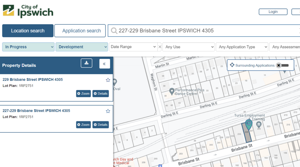
Start searching
You can now effortlessly search for the approval history of a particular subject site in Ipswich, along with access to all documents related to any development applications associated with it.
By doing so, you can delve into the details of what received approval and gain insights into any challenges or issues that arose during the assessment process. If you are contemplating a similar style of development in the same area, this information can serve as a valuable indication of potential challenges you might encounter in your own project.
Explore and set notifications
Utilising the toolbar located at the top of the map, you have the capability to search for approvals in the surrounding areas. Additionally, you can apply filters based on criteria such as approval date, development type, and approval status. This feature proves to be incredibly useful when conducting research on a specific development.
Moreover, the Developmenti system allows you to establish notifications, ensuring you stay informed about updates related to active development applications. This functionality serves as a valuable tool for monitoring not only your own applications but also those of others in a timely and efficient manner.

Some tips:
- Ipswich have a great set of guides for their system. Check them out here
- If you are researching a particular property, we recommend searching the surrounding properties so you know what else is could potentially be going on around the property. For example, if you’re searching 8 Fenton Road, try searching the whole street by way of the ‘map search’ function.
- Be patient, it can, unfortunately, take some time to load so if an address doesn’t show immediately, give it 10 seconds before you refresh the page;
- When typing in an address, just use the number and street name (leaving out the type of street or suburb) and let the system populate the address. We found that depending on how you write out the address, it might fail to find it. For example, ’10 Fenton Road, Yeronga’ won’t come up, but if you search ’10 Fenton’ it will populate the rest (note, this is not a real address);
- If you’ve found a site and you want to look at the surrounding approvals, make sure you zoom out slightly on the map, turn on ‘surrounding applications’ and change the ‘in progress’ filter to ‘all’ – a walk-through video below for reference;
- Use the ‘Map Search’ function to filter results and find similar applications to what you are wanting to do. For example, if you are wanting to lodge an application for a “Health Care Service” in the Annerley region, use the filters and see what other people have done – a walk-through video below for reference.
- You can register and ‘save’ searches which will allow you to set notifications about any changes in documentation, communications, or deadlines about an active development application – a walk-through video below for reference.
Ipswich Planning Scheme 2006
The current version of the Ipswich Planning Scheme can be found via the following link:
https://www.ipswichplanning.com.au/planning-documents/planning-scheme
Unfortunately, it is just a series of pdf’s and not very interactive. This scheme was also written under the Integrated Planning Act so is a very different layout than rest of the planning schemes in Queensland. We always recommend talking to a town planning consultant when reviewing a planning scheme. Reach out to one of our town planners to help!

Some tips:
- The level of assessment tables are found in the respective zone (i.e. there isn’t a central table of assessment).
- The overlay level of assessments are found in Part 11.
How to research flooding
Currently Ipswich City Council provides historical mapping for the flooding throughout the area. The link to this mapping is below. The search and functionality of this mapping is similar to the Interactive Mapping. Please follow the same steps.
https://maps.ipswich.qld.gov.au/weave/HistoricalFloodMap.html

Finding Services and Infrastructure
Currently there is no interactive way to find stormwater infrastructure from Ipswich City Council. The best option for this is to do a dial before you dig search. This service is free of charge, however you do need to create an account. This can be done here: https://www.1100.com.au/
The dial before you dig search will also provide information around other infrastructure that might run through the property.


Sewer and Water in Ipswich
Fortunately, in terms of sewer and water, Urban Utilities provide online mapping for the City of Ipswich via the following link which allows you to search your property and view the UU infrastructure near on on your property:
https://www.arcgis.com/apps/webappviewer/index.html?id=3d33e3db46894d46a9cffca08eae68b9